The Hydrologic Cycle
 Definition: The hydrologic cycle is the circulation of water from land, oceans, lakes,
and streams to the atmosphere and then back down to the earths surface.
Definition: The hydrologic cycle is the circulation of water from land, oceans, lakes,
and streams to the atmosphere and then back down to the earths surface.
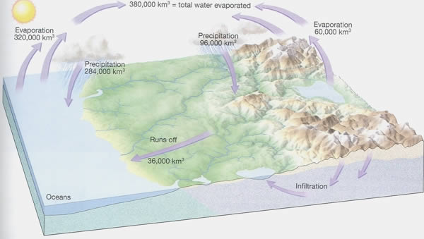
Figure: Earth's water balance. About 320,000 cubic kilometers of water are evaporated each
year form the oceans, while evaporation from the land (including lakes and streams)
contributes 60,000 cubic kilometers of water. Of this total of 380,000 cubic kilometers
of water about 284,000 cubic kilometers fall back to the ocean, and the remaining 96,000
cubic kilometers fall on earth's land surface. Since 60,000 cubic kilometers of water
evaporate from the land 36,000 cubic kilometers of water remain to erode the land during
the journey back to the oceans.
The figure shows earths overall water balance, or the volume of water that passes through each
part of the hydrologic cycle annually.
- The major component in the water cycle is Water itself. Water has special characteristic, it can change state very easily. It can exist in three different forms, solid, liquid, and gas. These different states that water can exhibit play a huge role in the Hydrologic Cycle.
- The other major components in the water cycle are Heat, supplied by the sun, and gravity.
- The Hydrologic Cycle consisted of Five components that contribute to its success.
- Evaporation/transpiration
- Condensation
- Precipitation
- Percolation which includes infiltration.
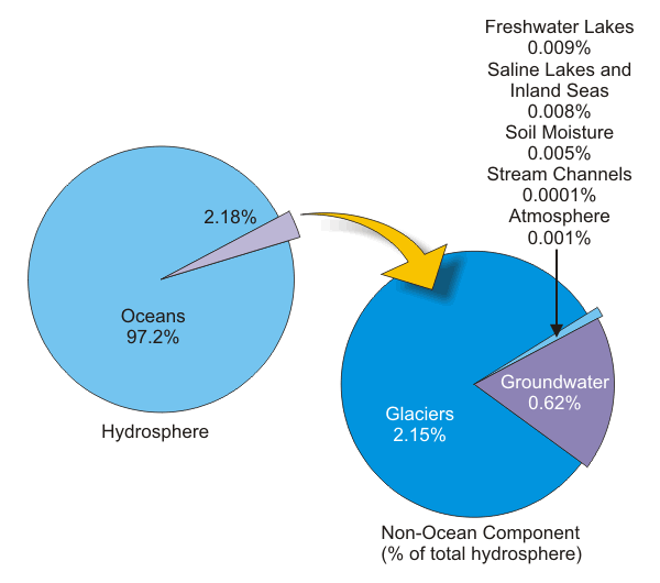
From the figure you can see that the vast bulk of water is stored in oceans at 97.2%
The remaining 2.8% is divided between glaciers at 2.15%, and leaving only 0.65% to be divided among lakes, streams, groundwater and the atmosphere
Surface Water
- Surface water is water that is open to the atmosphere
- It can be run off water from land, lakes, streams, and oceans
- Surface water plays a role in the recharge of groundwater at higher elevations by percolation through the soil
- Surface water is also the produced by groundwater discharge from the satuation zone
Ground Water
- Formation created by rain and other forms of precipitation.
- Exists in the pore spaces underground.
- Exists also in fractures of underlying rock.
- Discharges to rivers and ocean.
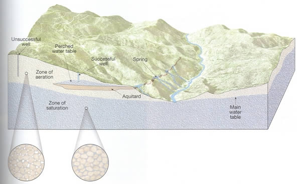
This diagram illustrates the relative positions of many features associated with groundwater.
Notes:
Zone of Aeration: The area above the water table where soil, sediment, and rock are not saturated with water.
Zone of Saturation: water not held near the surface penetrates downward until it reaches a zone where all of the open spaces in sediment and rock are completely filled with water.
The Water Table: is rarely level, but usually replicates the surface. Highest at hills and low in valleys. The major cause of the irregular surface of the water table is due to the slow movement of groundwater. Because of groundwater movement being so slow water tends to "pile up" beneath hills.
Springs
A spring is the result of an aquifer being filled to the point that the water overflows onto the land surface. The Water quality of springs can very greatly. If the water that is recharging the aquifer is contaminated, the water from the spring will also be contaminated. Also the water quality will depend on the types of lithology it is in contact with. You could get unwanted minerals from the spring, due to its location and contact to surrounding rock groups. Notes:
There are many different kinds of springs.
Depression springs are formed when the ground water tables surfaces at a low spot. These springs are usually shallow and flow depends on local precipitation
Contact Springs occur where water-bearing layers overlie less permeable rock or aquitards.
Fault Springs lie along fault lines where the earth has shifted forming a barrier to ground water movement.
Sinkhole Springs – water raises to the surface through sinkholes. The water in these sinkhole springs is under artesian pressure.